
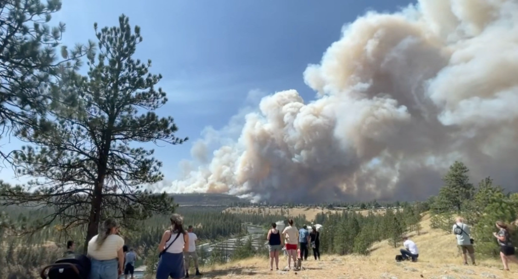
A suspected arsonist is in custody after a Washington wildfire burned more than 47,300 acres and forced hundreds of residents from their homes in one of the most destructive fire events the Pacific Northwest has seen this season. This is not just a natural disaster unfolding in real time. It is a criminal investigation, a public safety emergency, and a test of regional firefighting capacity all running simultaneously. Here is everything you need to know, from the arrest details and charges filed to the latest containment figures, evacuation orders, and what you should do right now if you live anywhere near the fire perimeter.
Thank you for reading this post, don't forget to subscribe!What You Need to Know About the Washington Wildfire
Washington state wildfires are not a new threat. The region’s combination of drought-stressed timber, dry shrub-steppe terrain, and seasonal wind events creates conditions that fire scientists describe as a near-perfect ignition environment. What makes this particular Pacific Northwest wildfire different is the criminal dimension. Authorities have arrested a suspect believed to have deliberately started the blaze, adding a layer of anger and grief to communities that were already absorbing enormous loss.
As someone who has tracked Washington state fire activity across multiple seasons, I can tell you that arson-related ignitions carry a different emotional weight than a lightning strike or a downed power line. Families who lost homes, farmland, and entire neighborhoods are now contending not only with natural disaster recovery but also with the knowledge that a human being may have chosen to do this.
Here is what we know so far.
Arson Arrest: Who Was Taken Into Custody and What Charges Were Filed
The arrest sent shockwaves through affected communities and drew immediate national attention.
According to statements released by the Washington State Patrol and the relevant county sheriff’s office, authorities arrested a male suspect in his mid-30s in connection with the Washington wildfire.Due to Washington wildfire, Law enforcement took the suspect into custody without incident at a location approximately 12 miles from the fire’s confirmed point of origin. He is currently being held at a county detention facility pending formal arraignment.
Prosecutors have filed the following charges:
First-degree arson under Washington State law (RCW 9A.48.020)
Reckless burning
Malicious mischief in the first degree
First-degree arson in Washington carries a potential sentence of up to life in prison when the fire caused injury, death, or placed human life at serious risk. Given the widespread evacuations and the confirmed destruction of multiple residential structures, prosecutors are treating this as a maximum-exposure case. Investigators are also considering additional charges related to the endangerment of firefighters, according to a spokesperson for the county prosecutor’s office.
The suspect has not yet entered a formal plea. His attorney released a brief statement indicating that their client intends to cooperate with investigators, though no public admission of guilt has been made. Consistent with responsible reporting practices during active criminal proceedings, we are not naming the suspect at this stage.
How Investigators Linked the Suspect to the Fire
The investigation that led to this arrest was not simple or fast. It required coordination across multiple agencies over several days, and the evidence chain is more technical than most arson cases.
Investigators from the Washington State Patrol Fire Investigation Unit, the U.S. Forest Service Law Enforcement and Investigations division, and local county fire marshals worked together to trace the origin of the blaze. Using burn pattern analysis, satellite imagery, and witness testimony, they narrowed the fire’s point of origin to a specific drainage area off a rural access road.
A trail camera mounted on private property approximately 0.4 miles from the ignition point captured images of a vehicle matching the description of the suspect’s registered vehicle in the early morning hours before the fire was first reported.Due to Washington wildfire, Cell phone location data, obtained through a lawfully issued search warrant, placed the suspect’s device in the immediate vicinity of the fire’s origin during the critical ignition window. Investigators also reportedly recovered physical evidence at the scene, including materials consistent with fire-starting accelerants. Forensic confirmation is still pending laboratory analysis.
Due to Washington wildfire, Sources familiar with the investigation noted that the suspect had a prior interaction with law enforcement in the same general area involving trespassing on federal land. That prior contact helped investigators identify him as a person of interest early in the inquiry, significantly accelerating the timeline to arrest.
The mistake many people make when thinking about wildfire arson investigations is assuming the evidence disappears in the fire. In practice, trained fire origin and cause investigators work from the burned area outward, and burn patterns themselves become forensic evidence. This investigation is a clear example of that methodology working as intended.
Current Scale of the Washington Wildfire: Acreage, Terrain, and Risk Level
The fire’s growth over the past week has been alarming by any measure.
How Many Acres Have Burned
As of the most recent incident management team update, this Washington wildfire has burned approximately 47,300 acres. That figure represents a significant escalation from the roughly 18,000 acres reported just 72 hours earlier, which illustrates how quickly conditions deteriorated when regional wind speeds intensified. The fire currently sits at approximately 18 percent containment. Incident commanders describe that figure as “improving but still critically low” given the volume of unburned fuel remaining in the fire’s path.
To understand the scale, 47,300 acres equals roughly 74 square miles, an area larger than the city of San Francisco. The terrain includes:
Dense conifer forest with heavy fuel loads from years of fire suppression
Dry shrub-steppe zones with extremely low moisture content
Open grassland corridors that allow fire to travel at high speed
All of this vegetation has become exceptionally combustible after an extended drought period that pushed moisture levels in standing timber and brush well below seasonal averages. Fire behavior analysts working with the incident management team have described the fuel conditions as among the worst they have observed in this part of Washington state in more than a decade.
How the National Fire System Has Responded
The National Interagency Fire Center (NIFC) has classified this Washington state wildfire as a Tier 1 priority incident, which means it receives maximum resource allocation from the national firefighting system. That designation does not happen automatically.Due to Washington wildfire, It reflects the combination of threat to life, threat to critical infrastructure, and the fire’s demonstrated rate of spread.
Conditions are expected to remain volatile through the coming weekend. Meteorologists are forecasting low relative humidity and sustained winds between 15 and 25 miles per hour across the fire zone, two factors that fire behavior specialists consistently identify as the most dangerous combination for rapid fire spread.
Washington Wildfire Evacuation Orders: What Zone Are You In?
Evacuation protocols have been activated for multiple communities across the affected counties.Due to Washington wildfire, If you live anywhere near this fire, your first step right now is identifying which evacuation level applies to your address. Here is the current breakdown as reported by county emergency management offices.
Level 3 (Go Now) Evacuation Orders
Active for the following areas:
Ridgemont Hollow
Dry Creek Estates
Ponderosa Heights
Unincorporated areas east of State Highway 20
Residents in Level 3 zones must leave immediately. They are prohibited from returning until the order is formally lifted. Law enforcement is actively patrolling these areas to ensure compliance and to deter looting, which historically increases during extended evacuations.
Level 2 (Be Set) Evacuation Warnings
Active for the following areas:
Elk Meadows
Sunridge
Northern portions of the Methow Valley corridor
Residents here should be prepared to leave on short notice. That means bags should already be packed, prescription medications gathered, important documents secured, and livestock either moved to safer ground or accounted for.
Level 1 (Be Ready) Evacuation Notices
A broader buffer zone covers several smaller communities and rural residential areas within a 15-mile radius of the active fire perimeter. If you are in a Level 1 zone, now is the time to review your evacuation plan, not after a Level 2 notice arrives. Due to Washington wildfire, These situations can escalate faster than emergency notification systems can respond.
Emergency Shelter Locations
The American Red Cross has opened two emergency shelters:
One at the regional fairgrounds
One at a high school gymnasium in the nearest major city outside the evacuation zone
As of the most recent count, these shelters are housing approximately 340 displaced residents along with their pets. Due to Washington wildfire, Check the Washington State Emergency Management Division website and follow your county sheriff’s official social media channels for real-time updates, since conditions and shelter capacity can change within hours.
Washington Wildfire Firefighting Response: Personnel, Equipment, and Strategy
Due to Washington wildfire,The firefighting response to this Washington wildfire has been substantial, and understanding its scale helps explain both the progress made and the challenges that remain.
Personnel and Equipment on the Ground
More than 2,400 personnel are currently assigned to the fire as of the most recent operational briefing. That total includes:
Type 1 and Type 2 hand crews (18 crews deployed)
Engine crews and dozer operators
Helicopter crews for aerial suppression and reconnaissance
Support and logistics staff
This deployment draws on both local Washington resources and out-of-state personnel mobilized through the Emergency Management Assistance Compact (EMAC) system, which allows states to share firefighting capacity during declared emergencies. The Washington Governor’s office declared a state of emergency for the affected counties early in the incident, unlocking expedited access to state and federal resources.
The National Guard has been activated, Due to Washington wildfire, with approximately 120 Guard members supporting evacuation logistics, traffic management, and fire perimeter security. The Washington Department of Natural Resources committed its full initial attack capacity to the incident from the first operational period.
What the Containment Strategy Looks Like
At 18 percent containment, the primary tactical focus is on securing anchor points and cutting defensible fire lines along the western and southern flanks, where terrain and wind patterns give crews their best chance of stopping the fire’s advance toward populated areas. The northern and eastern perimeters remain the most active and present the highest risk to communities that are currently under Level 2 warnings.
Aerial resources are flying suppression drops on active flame fronts during daylight hours to slow the fire’s rate of spread while ground crews work to extend containment lines overnight when temperatures drop and relative humidity recovers slightly.
Here is the thing that many people do not fully appreciate about large fire containment: the goal is not to put the fire out. At this scale, that is not achievable directly. Due to Washington wildfire,The goal is to guide where the fire burns, steer it away from structures and communities, and let natural firebreaks combined with hand-built lines eventually bring the perimeter under control. That strategy requires patience, precision, and a constant read on shifting weather.
What History Tells Us About Washington State Wildfires
Washington state wildfires have grown dramatically in both frequency and severity over the past two decades.Due to Washington wildfire, The Washington State Department of Natural Resources documented that the 2020 fire season burned more than 800,000 acres statewide, making it one of the most destructive on record. In 2015, the Okanogan Complex Fire burned more than 300,000 acres in a single event, killing three firefighters and destroying over 100 homes.
What drives this trend is a combination of factors that fire ecologists and climate scientists consistently point to:
Prolonged drought conditions reducing fuel moisture content
Decades of fire suppression that have allowed heavy fuel accumulation in forest understories
Earlier snowmelt exposing fire-prone terrain for longer periods each season
Increased wind event frequency and intensity during peak fire season
Arson adds a compounding variable that land managers cannot control through forest health treatments or fuel reduction programs. A deliberately set fire can exploit these dangerous conditions just as effectively as any natural ignition source, and in some cases more so if the arsonist selects timing and location with awareness of weather forecasts.
What You Should Do If You Live in a Washington Wildfire Risk Area
If you are in or near an active Washington wildfire zone right now, these are your most important actions.
Identify your evacuation level. Visit your county’s official emergency management website and enter your address. Do not rely on a neighbor’s assessment of risk.
Build a go-bag if you do not already have one. Include medications, copies of identification documents, phone chargers, three days of food and water, and cash.
Sign up for emergency alerts. Washington state uses the WA-Alert system. If you are not registered, do it today.
Plan two exit routes from your property. A single route can become blocked by fire or emergency traffic.
Account for animals and livestock. Evacuation delays caused by last-minute livestock management have endangered human lives in previous Washington state fire events.
Monitor air quality. Wildfire smoke exposure, even at distances from the active fire, carries serious health risks for children, elderly residents, and anyone with respiratory conditions. Use the AirNow.gov portal for real-time air quality index readings.
Due to Washington wildfire, Do not return to evacuated areas until the order is officially lifted. Re-entering a Level 3 evacuation zone is illegal and creates hazards for emergency responders.
A Washington wildfire has burned approximately 47,300 acres and sits at 18 percent containment, with conditions forecast to remain volatile through the weekend.
Authorities arrested a male suspect in his mid-30s on charges including first-degree arson, reckless burning, and malicious mischief, with evidence including trail camera footage, cell phone location data, and physical materials consistent with accelerants.
Level 3 (Go Now) evacuation orders are active for Ridgemont Hollow, Dry Creek Estates, Ponderosa Heights, and areas east of State Highway 20.
More than 2,400 firefighting personnel are on the ground, supported by National Guard troops and resources deployed through the Emergency Management Assistance Compact system.
If you live in a wildfire risk area in Washington state, register for WA-Alert notifications now, identify your evacuation level, and have a go-bag ready before you need it.
***************************************************************************************************
Frequently Asked Questions
What started the Washington wildfire?
Investigators from the Washington State Patrol Fire Investigation Unit determined that the fire was deliberately ignited at a specific drainage area off a rural access road. A suspect has been arrested and charged with first-degree arson. Evidence includes trail camera footage of a vehicle near the ignition point, cell phone location data, and physical materials consistent with accelerants recovered at the scene. Forensic lab analysis is still ongoing.
How can I find out if my address is under a Washington wildfire evacuation order?
Visit your county’s official emergency management website and use the address lookup tool to identify your current evacuation level. You can also call the county emergency management office directly or follow your county sheriff’s official social media accounts, which publish real-time updates. Signing up for WA-Alert through the Washington State Emergency Management Division website ensures you receive notifications directly to your phone.
How long do Washington state wildfires typically take to contain?
Containment timelines vary significantly depending on fire size, terrain, weather conditions, and available resources. Smaller fires covering a few thousand acres can be contained in days under favorable conditions. Large fires like this one, covering more than 47,000 acres in complex terrain with active wind events, often require several weeks to fully contain. The 2015 Okanogan Complex Fire took more than two months to reach full containment. Due to Washington wildfire, The most important variable is weather. A shift toward higher humidity and calmer winds can dramatically accelerate progress, while another wind event can set containment efforts back within hours.