
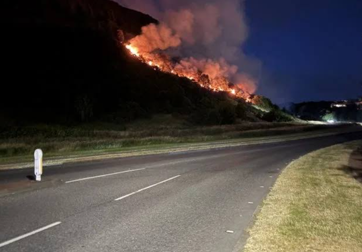
A wildfire tearing through the Scottish Highlands right now is unlike anything many local residents and emergency responders say they have witnessed in recent memory. Scotland wildfire conditions have deteriorated so rapidly that the Scottish Fire and Rescue Service has formally declared this a major incident, stretching resources across one of Britain’s most remote and ecologically sensitive landscapes.
Thank you for reading this post, don't forget to subscribe!I have been tracking this developing story closely, pulling together verified reports from fire services, meteorological data, and on-the-ground community accounts. What follows is the clearest, most detailed picture available of what is happening, why it escalated so fast, and what it means for the future of Scotland’s moorlands, peatlands, and Highland communities.
Key Facts at a Glance
Before diving into the detail, here is what you need to know immediately:
The Scottish Fire and Rescue Service (SFRS) has declared the event a major incident
Multiple agencies are responding, including Police Scotland, the Scottish Ambulance Service, and Forestry and Land Scotland
Peat deposits underlying the affected terrain mean the fire could smolder for weeks after surface flames are extinguished
Several Sites of Special Scientific Interest (SSSIs) and at least one National Nature Reserve fall within or adjacent to the fire perimeter
Evacuation advisories are in place for rural properties and farming operations near the fire front
Overview of the Current Scotland Wildfire Situation
The scale of this Scotland wildfire did not emerge overnight. It built over weeks of conditions that fire behavior researchers would classify as extreme, then ignited and spread faster than early incident reports suggested it would.
When reports first began coming in from the Scotland wildfire
Highlands, the initial dispatches were alarming but not entirely surprising. Prolonged dry spells, unseasonably warm temperatures, and critically low soil moisture levels had set the stage for exactly this kind of event. Fire services quickly escalated their response as it became clear the blaze was not behaving like a manageable muir fire. It was behaving like a wildfire operating in extreme weather.
The SFRS, which became Scotland’s single national fire service following the 2013 merger of regional brigades, coordinates all major incident responses of this type. That major incident designation triggers a multi-agency response structure involving:
Police Scotland (scene security, road closures, public communications)
The Scottish Ambulance Service (casualty planning and standby response)
Local authority emergency planning teams (evacuation support, welfare provisions)
Forestry and Land Scotland (land access, firebreaks, ecological assessment)
Community members in nearby villages described smoke visible from miles away. Several reported that the smell of burning vegetation had been present for days before the fire reached its current scale, suggesting the blaze had been growing steadily before formal escalation procedures were triggered.
Evacuation advisories have now been issued for several rural properties and farming operations within the immediate fire perimeter. The SFRS has urged the public to stay well clear, emphasising that unpredictable wind shifts can alter fire behavior within minutes, creating dangerous conditions even for those who believe they are standing at a safe distance. Multiple single-track roads serving as access routes into the affected area have been closed.
Where the Scotland Wildfire Is Burning
Terrain and Landscape in the Fire Zone
Based on current SFRS communications and verified regional news sources, the fire is burning across moorland and mixed vegetation zones in the central and northern Highland region. The terrain here is characterised by deep peat deposits, heather, bracken, and scattered Scots pine and birch woodland, all of which provide substantial fuel loads under dry conditions.
The specific geography of the Scottish Highlands creates unique and serious challenges for fire suppression operations. Steep valley sides, remote glens, and severely limited road access make getting equipment and personnel to the fire line logistically complex in ways that flatland wildfire operations simply do not face. Aerial imagery circulating among emergency management professionals and conservation groups shows the fire’s footprint as a dark, expanding scar cutting across what would normally be a richly textured Highland landscape of greens, purples, and autumn browns.
Protected Areas at Risk
One of the most serious ecological dimensions of this Highland wildfire involves land designation. Several Sites of Special Scientific Interest and at least one National Nature Reserve are reported to be within or immediately adjacent to the current fire perimeter. SSSIs carry legal protection under the Nature Conservation (Scotland) Act 2004, and damage to their qualifying habitats triggers obligations on both landowners and public authorities to report, assess, and remediate where possible.
The presence of protected areas within the fire zone adds a layer of urgency that goes well beyond immediate human safety concerns. Some of the specialist species dependent on intact Highland moorland and bog habitats, including golden plover, dunlin, and several nationally scarce plant communities, are highly vulnerable to severe fire events and take decades to recover even under the best post-fire management conditions.
How the Scotland Wildfire Started and Spread
Reported Causes and Ignition Points
Determining the exact cause of a wildfire while it is still actively burning is always difficult, and it is important to distinguish clearly between confirmed information and what remains under investigation. What SFRS officials have confirmed publicly is that the fire’s origin point is believed to be in an area of open moorland. Investigators will conduct a full post-incident review once the blaze is brought under control.
Historically, wildfires in the Scottish Highlands have several common causes. According to data published in the SFRS annual wildfire reports:
Deliberate fire-setting is one of the most frequently recorded causes during dry periods
Accidental ignition from discarded materials, including barbecue equipment and cigarettes, is a recurring trigger in areas accessible to recreational visitors
Muirburn operations that escape control have been cited in previous incidents, particularly when weather conditions change unexpectedly during or after a licensed burn
Muirburn, the controlled burning of heather and other vegetation carried out legally as part of grouse moor management, now operates under a licensing framework introduced through legislation developed from the Land Reform (Scotland) Act and subsequent regulations. That framework exists precisely because uncontrolled muirburn has historically been a risk factor in larger Highland fire events.
Natural Scotland and environmental monitoring agencies had already issued elevated wildfire risk warnings for the region in the days immediately preceding this fire’s outbreak. That fact will likely be central to any subsequent review of whether adequate preventive measures were in place before ignition occurred.
Weather and Wind Conditions Fueling the Blaze
The meteorological context for this Scotland wildfire is critical. It explains why the fire grew so rapidly and why suppression efforts have faced such severe difficulty.
The UK Met Office recorded well-below-average rainfall across significant parts of the Scottish Highlands in the weeks leading up to the outbreak. Soil moisture deficit readings, which measure how dry the ground has become relative to seasonal norms, were at levels more typically associated with late summer in southern England than with the Scottish Highlands at this time of year.
Wind has been the fire’s most powerful accelerant. Gusts in the affected area reached speeds capable of carrying embers significant distances ahead of the main fire front, a phenomenon known as spotting. Spotting allows new ignition points to appear well beyond the zone firefighters are actively working, effectively opening new fronts faster than crews can address them. Meteorological data from regional weather stations shows sustained winds of between 20 and 35 miles per hour with higher gusts at elevation, which is more than sufficient to drive rapid spread across dry heather moorland.
Relative humidity has also remained stubbornly low during daylight hours, dropping below 25 percent on several afternoons during the active fire period. Fire behavior researchers recognise that relative humidity below 25 percent, combined with wind speeds above 15 miles per hour and low fuel moisture content, creates conditions classified as extreme fire weather.Scotland wildfire , By that measure, this Scotland wildfire has been operating under extreme conditions for multiple consecutive days.
Scale and Severity of the Scottish Highlands Wildfire
Estimated Land Area Affected
Precise acreage figures for an actively burning wildfire are inherently provisional and change as the fire perimeter expands or contracts under firefighting pressure. With that caveat clearly stated, current estimates from official sources and verified mapping data suggest the Scotland wildfire has affected several thousand acres of moorland, peatland, and associated upland vegetation.
To put that scale in context, the largest wildfires recorded in Scotland’s modern fire history have ranged from a few hundred to several tens of thousands of acres depending on conditions. Several thousand acres of burning peatland and heather represents a significant and serious event by any historical comparison.
Why Peat Fires Are a Unique Challenge
Peat fires present a challenge that many people outside Scotland or Ireland may not fully appreciate, and it is worth explaining clearly.
Peat is partially decomposed organic matter that has accumulated in waterlogged ground over thousands, and in some locations tens of thousands, of years. Scotland wildfire ,Unlike mineral soil, peat can burn underground as well as at the surface. A peat fire can smolder for days, weeks, or even months after the visible surface fire appears to have been extinguished. Full containment and declared extinction of a major peat fire is therefore a lengthy and resource-intensive process that can drag on long after media and public attention has moved elsewhere.
Scotland holds approximately 23 percent of the United Kingdom’s total peat resource, according to figures published by the James Hutton Institute, one of Scotland’s leading environmental research organisations. Peat in its intact, waterlogged state stores enormous quantities of carbon accumulated over millennia. When it burns, it releases that carbon rapidly. A single large peat fire event can produce carbon emissions comparable to the annual emissions of a medium-sized industrial facility, a fact that gives wildfire in Scotland a climate dimension that extends well beyond the immediate landscape damage.
Comparison to Previous Major Wildfires in Scotland
To put the current situation in historical context, several major wildfire events from Scotland’s recent past provide useful reference points.
The Moray wildfires of April 2019 are frequently cited as a benchmark for large-scale Highland fire events in the modern era. Fires burned across substantial areas of moorland during that period, requiring multi-day SFRS operations and prompting significant national media coverage and political scrutiny of wildfire preparedness.
The Easter Ross fires of 2011 similarly highlighted the vulnerability of Scotland’s upland landscapes to rapid fire spread during periods of low rainfall and elevated wind. Both events generated post-incident reviews that informed current SFRS wildfire strategy, including the development of dedicated wildfire tactical advisor roles and the adoption of aerial observation assets for large landscape fires.
What makes the current Scotland Highland wildfire particularly significant is the combination of factors converging simultaneously: extreme meteorological conditions, substantial peat fuel loads, proximity to protected ecological sites, and a period of heightened public and political scrutiny around land management practices in the Highlands.
Ecological and Environmental Consequences of the Scotland Wildfire
Impact on Peatland Carbon Stores
Intact Scottish peatlands are one of the country’s most important natural carbon stores. NatureScot, Scotland’s nature agency, estimates that Scottish peatlands store approximately 1.6 billion tonnes of carbon, making their protection a central element of Scotland’s climate commitments under the Climate Change (Scotland) Act 2009 and subsequent net-zero legislation.
Wildfire on peatland does not merely damage surface vegetation. It dries out the upper peat layers, makes them more susceptible to future fire events, and can fundamentally alter the hydrology of a peat bog by damaging the surface structure that retains water. In practice, a severely burned peat bog may take 20 to 50 years to recover meaningful ecological function even with active restoration intervention.
Impact on Wildlife and Biodiversity
The Scottish Highlands support a suite of upland species that are rare or absent elsewhere in the United Kingdom. Some of these species can benefit from low-intensity managed burning in the long term, as it creates habitat diversity. Severe, uncontrolled wildfire is a different matter entirely.
Species likely to be affected by this Scotland wildfire include:
Red grouse and black grouse: nest and chick mortality during active fire events
Hen harrier and short-eared owl: dependent on prey populations that will be temporarily reduced across burned areas
Mountain hare: significant mortality risk from fire events on moorland
Freshwater fish: ash and sediment loading in streams and rivers flowing through burned catchments can cause water quality degradation and oxygen depletion
Rare invertebrates and bog mosses: highly specific habitat requirements that may take decades to re-establish after a severe fire
The Royal Society for the Protection of Birds (RSPB), which manages several reserves in the Scottish Highlands, has historically flagged the tension between intensive grouse moor management burning and biodiversity outcomes. The current wildfire, whatever its ultimate cause, will intensify that debate.
Emergency Response to the Scottish Highlands Wildfire
What the SFRS and Partner Agencies Are Doing
The multi-agency response to this Scotland wildfire is operating across several simultaneous workstreams.
SFRS wildfire crews are deploying specialist equipment including high-volume water carriers, all-terrain firefighting vehicles, and hand tools for cutting firebreaks in terrain inaccessible to wheeled vehicles. Aerial assets, where available and weather conditions permit, provide critical observation and can support water bombing operations on accessible sections of the fire perimeter.
Forestry and Land Scotland personnel are working alongside SFRS crews to identify and exploit existing firebreaks, tracks, and watercourses that can serve as natural control lines. Creating new firebreaks by cutting or burning vegetation ahead of the advancing fire front is a standard technique in large landscape fires, though it carries its own risks if wind direction changes unexpectedly during the operation.
Police Scotland has implemented road closures and is managing public exclusion zones around the active fire perimeter. The Scottish Ambulance Service maintains a standby presence, and local authority emergency planners are coordinating welfare support for residents who have been evacuated or who face extended disruption.
Advice for the Public
If you are planning travel to the affected Highland area or if you live or work near the fire zone, the current guidance from SFRS is clear:
Avoid the area entirely until SFRS lifts its public exclusion advisory
Follow road closure instructions and do not attempt to bypass them on foot or by vehicle
Report any new fire activity you observe to 999 immediately, giving your location as precisely as possible
If you are evacuated, follow local authority guidance on welfare centre locations and do not return to your property until officially advised it is safe to do so
Monitor air quality if you are in a downwind area, and follow NHS Scotland guidance if you have respiratory conditions and experience symptoms related to smoke exposure
What This Scotland Wildfire Means for Land Management Policy
The Debate Around Muirburn and Grouse Moor Management
Every major wildfire event in the Scottish Highlands reignites the policy debate around how upland land is managed. The Muirburn (Scotland) Act 2023 introduced a licensing system for controlled burning, replacing a previous code of practice with legally binding requirements. Supporters of the licensing approach argue that it provides better oversight and reduces the risk of controlled burns escaping. Critics argue that it does not go far enough and that the fundamental land use model on driven grouse moors creates a fire-prone landscape.
That debate will intensify in the wake of this wildfire, particularly given the ecological sites within its perimeter. The Scottish Government’s land reform agenda, which includes proposals affecting large landholding structures in the Highlands, intersects directly with questions about who bears responsibility for wildfire prevention and post-fire landscape recovery.
Climate Change and the Future of Scotland Wildfire Risk
The conditions that produced this wildfire are not anomalous in the context of Scotland’s changing climate. They are increasingly normal.
The UK Climate Projections (UKCP18) published by the Met Office project that Scotland will experience warmer, drier summers and more frequent and intense dry spells over the coming decades. Research published by the Centre for Ecology and Hydrology has linked increasing wildfire frequency and severity in the UK uplands to these changing climate patterns, noting that areas that historically saw little fire activity are now experiencing conditions that would have been classified as exceptional in the 1970s or 1980s.
The mistake most people make when discussing Highland wildfire risk is treating each event as a one-off anomaly rather than as part of a clear trend. What the data actually shows is a directional increase in fire weather conditions across Scotland that will require systematic policy responses, not just reactive emergency management.
Key Takeaways
The Scotland wildfire currently burning in the Scottish Highlands has been declared a major incident by the SFRS, triggering a full multi-agency emergency response
Deep peat deposits in the affected area mean the fire could smolder underground for weeks or months after surface flames are controlled, making complete extinction a lengthy process
Extreme meteorological conditions, including sustained high winds, very low relative humidity, and well-below-average rainfall, drove rapid fire spread and have complicated suppression operations
Scotland’s peatlands store approximately 1.6 billion tonnes of carbon according to NatureScot, meaning large-scale wildfire in these landscapes carries significant climate as well as ecological consequences
Changing climate projections under UKCP18 indicate that extreme fire weather conditions in the Scottish Highlands will become more frequent, not less, demanding a shift from reactive emergency response toward proactive landscape and policy planning
Frequently Asked Questions
What is causing wildfires to increase in Scotland?
Scotland’s increasing wildfire frequency is driven by a combination of climate change and land management factors. UK Met Office climate projections show Scotland is experiencing warmer, drier conditions with longer dry